Land Surveying Tools for AutoCAD, BricsCAD, GstarCAD, ZWCAD and progeCAD
Create complete survey plans from point import to final PDF — including terrain models, contours, maps, coordinate tables, annotations, title blocks and GIS/CAD exchange, directly inside your CAD environment — with speed, accuracy, and a workflow that fits the way you already work.
Works with full versions of AutoCAD 2016+, BricsCAD V20+, GstarCAD 2021+, ZWCAD 2021+ and progeCAD 2026+.
Complete survey plans
Produce topographic survey drawings from point import to final PDF with scale-aware drafting automation.
GIS / CAD exchange
Use background maps and import/export KML, KMZ, SHP, JSON/GeoJSON and georeferenced imagery.
Terrain & DTM
Create TIN surfaces, contours, longitudinal profiles, cross sections and cut/fill volume calculations.
CAD productivity
Speed up everyday CAD production with scale-aware texts, symbols, layers, hatches, dimensions and plotting tools.
SDBOX turns your CAD platform into a complete topographic survey production environment. It helps land surveyors and civil engineers move from raw survey points to clean, printable deliverables with terrain modelling, maps, GIS/CAD exchange and drafting automation inside AutoCAD-compatible software.
What is SDBOX
See how SDBOX supports the complete topographic survey workflow: points, terrain, maps, GIS exchange, annotations, tables, title blocks and final output.
About us
A practical tool developed from day-to-day engineering and surveying work, now packaged for AutoCAD-compatible CAD platforms.
Our story →Contents – Complete survey drawings, terrain, maps and CAD productivity
A focused production toolkit for land surveyors, civil engineers and CAD technicians who need complete topographic survey drawings, terrain deliverables, maps and GIS/CAD exchange.

Survey Plan
Complete topographic survey plan drafting — from survey point import to the final automated PDF output. Includes: survey point import • existing conditions drafting • building identification • terrain and area hatches • cartographic symbols • annotations • elevation levels • reference grid and coordinate system • planning and regulatory lines • zoning/planning indications • boundary drafting • property documentation • building documentation • adjoining parcel buildability checks • title blocks, statements and building terms • map and image extracts • coordinate tables • print layouts • coordinate export • chainage/stationing
Read more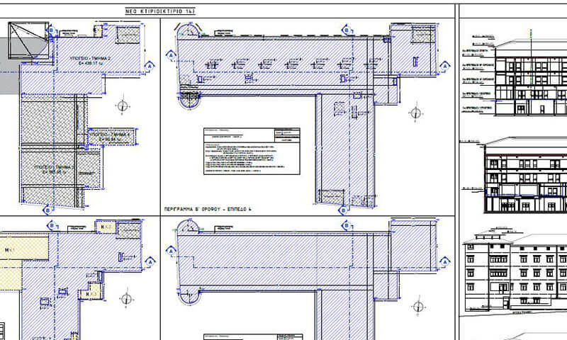
DTM
Digital terrain model creation, editing and drafting tools. ● TIN generation with break-lines ● triangle editing ● color gradient rendering ● cross-sections on one or multiple terrains ● longitudinal profiles on TIN or from 3D polylines ● contour calculation and preview drafting ● contour smoothing ● sections along contours ● volume calculation of cut and fill operations.
Read more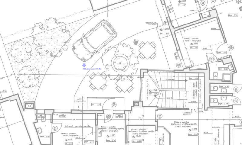
Maps
Direct access to multiple background maps and Google Earth with just two clicks on the drawing screen • Automatic import of map tiles or map captures • Coordinate conversion tools • Import/export of SHP and JSON spatial data • Import of geo-referenced images (World File, GeoTIFF) • Export of georeferencing data • Publishing all drawing objects to Google Earth, preserving layers and colors • Import of KML/KMZ files with full structure (folders, colors, labels) • Google Street View integration.
Read more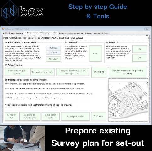
Set-out Plan
• Edit third party designs • Prepare existing Survey plan for set-out • Export existing marks and control points • Add and export Set-out points • Print design for Site.
Read more
Operations and Calculations
Tools for operations and calculations with values from texts, blocks, and drawing objects: perform math operations, document areas, and analyze geometry. ● Math operations on Block/text values ● Dimension-based calculations ● Area by center point● Subdivide area into plots ● Area report from polylines ● Area documentation ● Text-to-number processing ● Length and area calculations ● Deviation analysis ● Slope calculation.
Read more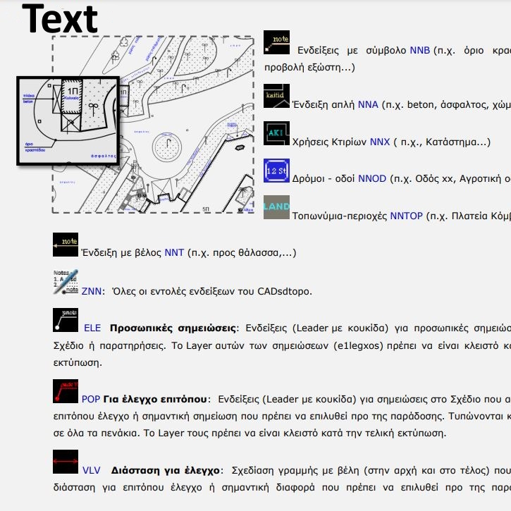
Texts
Advanced text tools for annotations, notes, and labels • 19 annotation types and usage indicators • 7 styles of notes and headings • Built-in text editor • Auto-alignment, line spacing, and padding • Import/export to file • Bulk text management.
Read more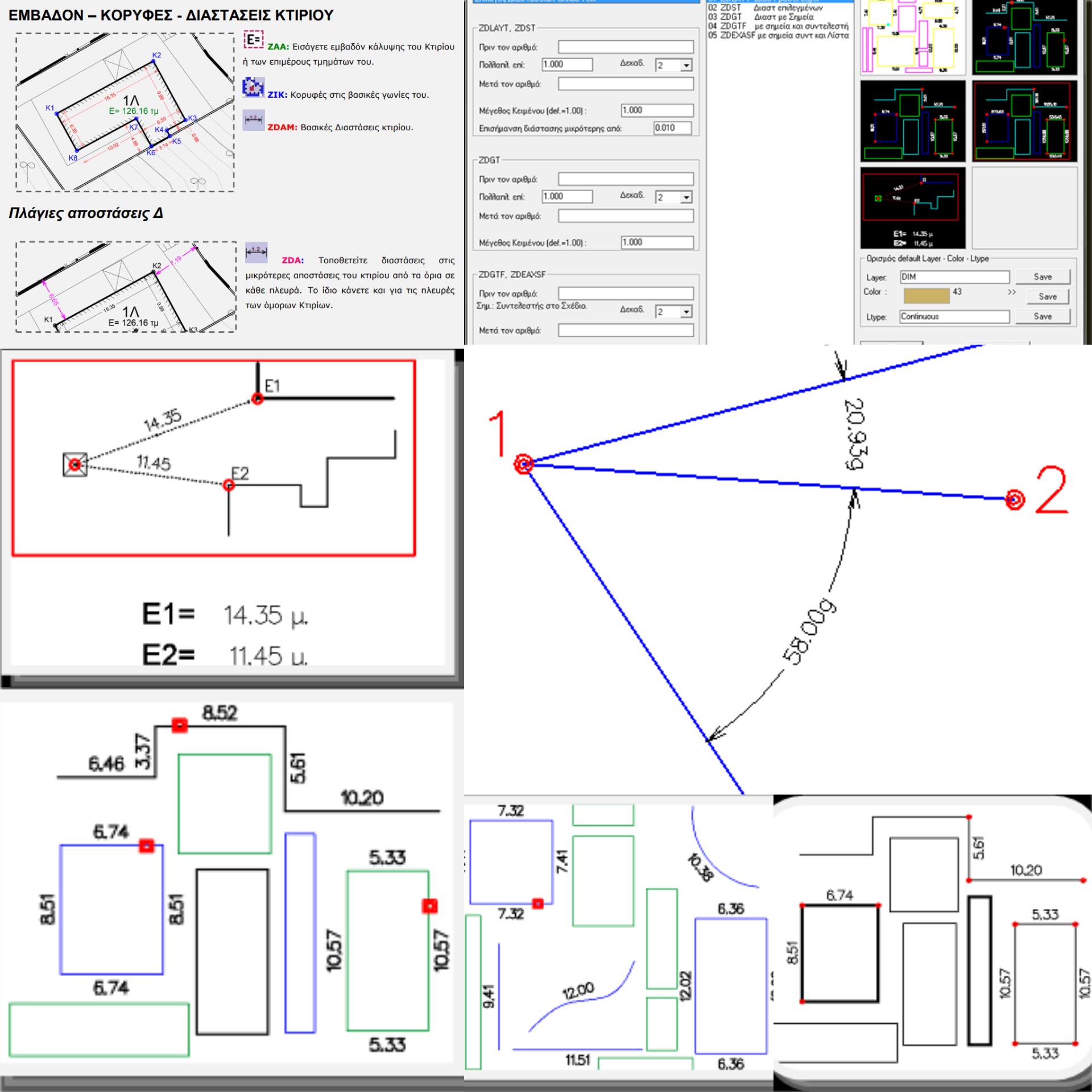
Dimensions
Smart dimensioning tools that adapt to your print scale. ✔ AutoCAD-style dimensions: Offsets, object-to-object, cross-section, angles, azimuths, diameters, radii, centers, arc length. ✔ Text-based dimensions: Layer-based, from points, offsets, path length calculation. Includes powerful editing and management tools.
Read more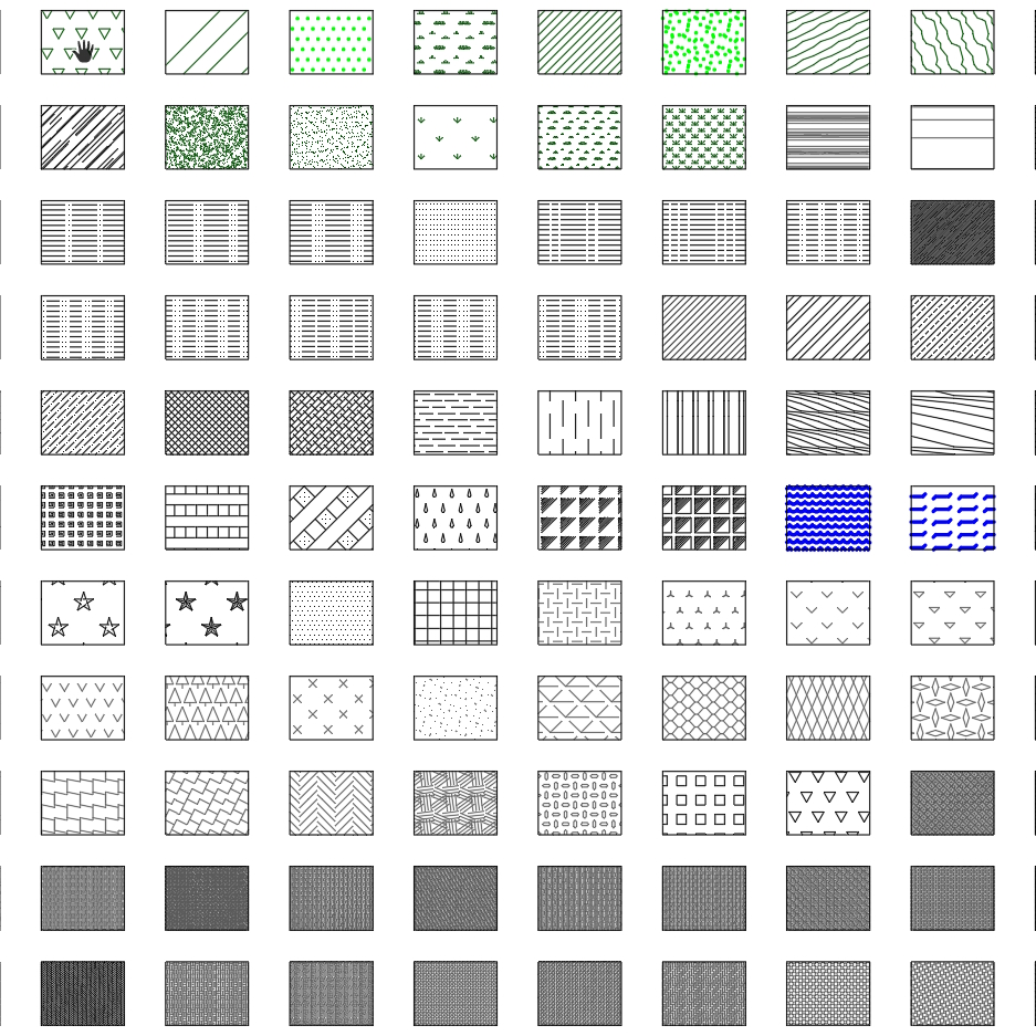
Hatch patterns
Hatch patterns are automatically scaled to match your print scale. The library includes: 17 regular line patterns, 15 dashed, 23 solid colored, 5 for terrain, 2 for concave surfaces, 29 textures, 5 wood, 24 pavings, 14 floor tiles, 3 for glass, 24 wall types, 5 section cuts, 14 parquet, and 9 forest areas.
Read more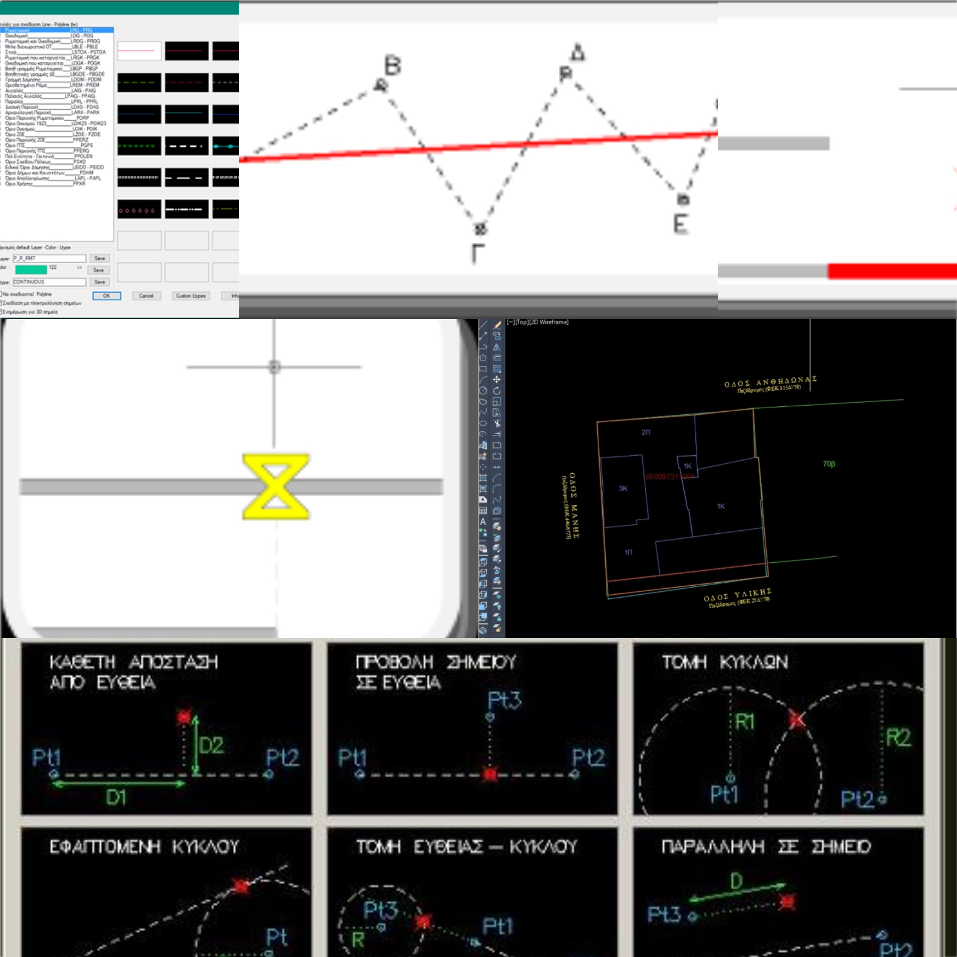
Lines
Line drawing and editing tools, with support for calculations, transformations, and batch operations. ● Draw using over 300 predefined line types ● Snap to fixed Y or X direction ● Best-fit line ● Midline between two polylines ● Oriented rectangle ● Custom rectangle by one point per side ● Perpendicular from point ● Extend or trim to any point ● Set total length or increment ● Break at any point ● Remove zero-length lines ● Measure multiple objects ● Join into polyline with filters ● Spline to polyline ● Reverse direction ● Add/remove vertex ● Convert polyline to arcs, lines, or spline ● Generate line legend.
Read more
Blocks
Insert, edit, and manage all CAD blocks: fixed-size or scale-aware symbols, automatic numbering, symbols in circles or labels, attribute editing and block matching, symbol counting and tabulation, export blocks to file, xref handling, symbol legend generation.
Read more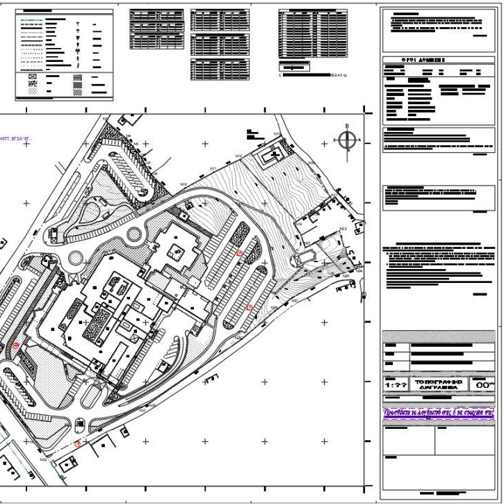
Title blocks
Automated insertion of title blocks, legends, declarations, and notes, all scale-aware based on plot scale. ● Included: A4–A0 layouts, project base info, short descriptions, and legends for lines, symbols, hatches, texts, and openings.
Read more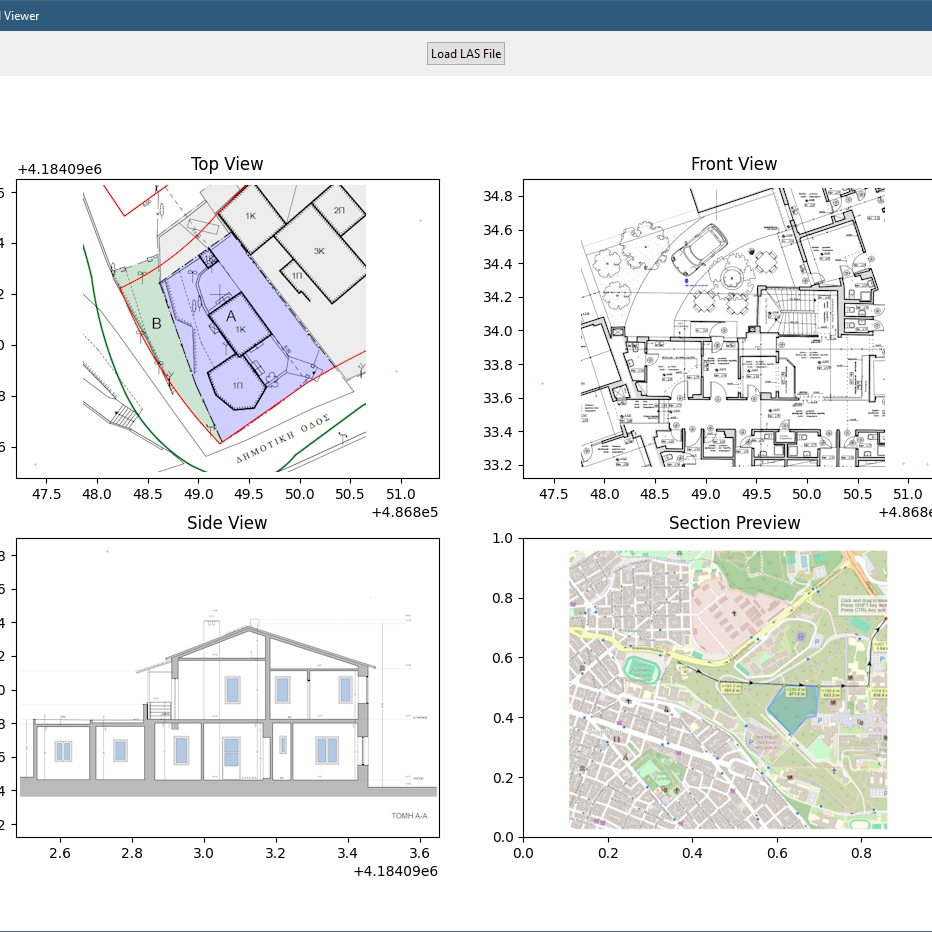
View
Useful tools for managing the screen, viewports, and layouts. ● Split screen view ● Set rotation in Model and reset ● Layout generation ● Viewport control and management within layouts.
Read more
Photos
• Photo insertion with auto-scaling and labeling • Location and orientation markers • Photo sheet generation • Batch copy and management • Auto-launch of image files.
Read more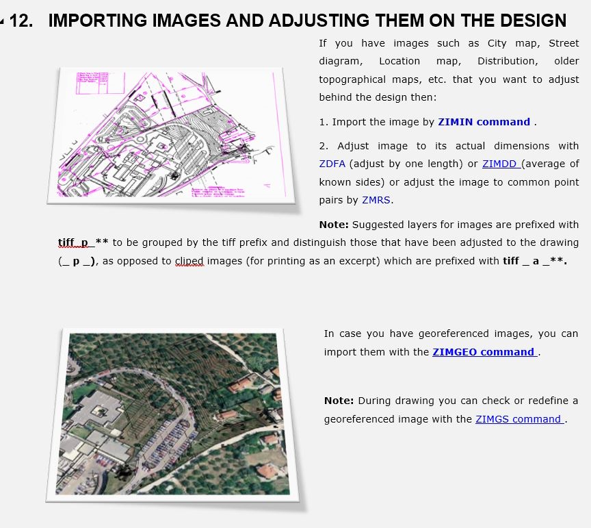
Images – Pdf
Image & PDF handling with precision and flexibility • Bulk path update • Insertion with optimized settings • Scaling to true dimensions • Auto-labeling of image names • Batch management tools.
Read more
Layers
Layer management and editing tools. ● View layer lists ● Isolate layers ● Grey-out all but selected ● Toggle layer visibility ● Copy/move objects to layers ● Auto-rename from file ● Add prefixes/suffixes ● Import layer filters ● Change color/lineweight on-screen ● Import layers from file ● Generate layer legend.
Read more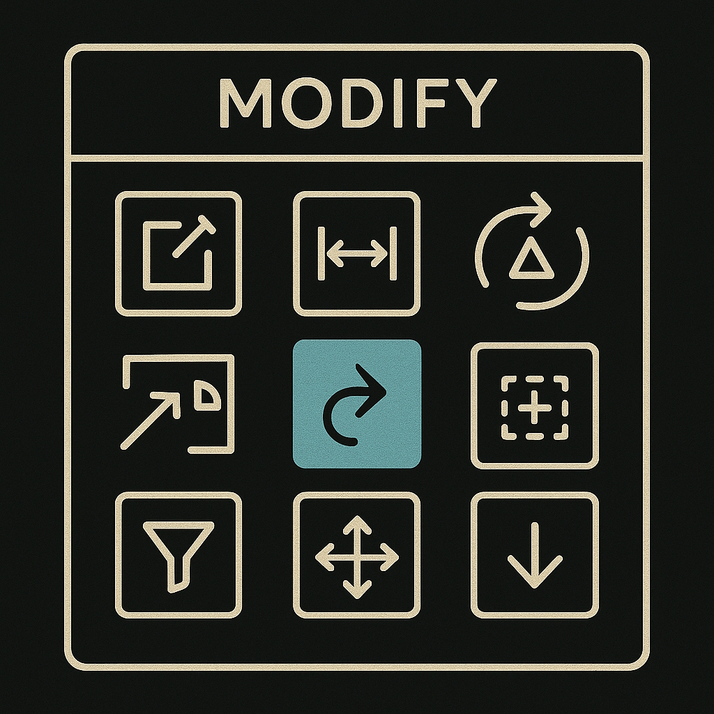
Modify
Bulk modification of multiple objects, batch replacements, and adjustments. ● Fit to average values ● Convert to true dimensions ● Adjust using side lengths ● Handle different print scales ● Replace blocks ● Object selection/preview ● Property changes using filters ● Adjust LtScale / LtWeight / Hatch scale by factor ● Copy-move-erase with filters ● Move along X or Y only ● Erase by length ● Scale-Mirror-Rotate by insertion point ● Flatten to Z=0.
Read more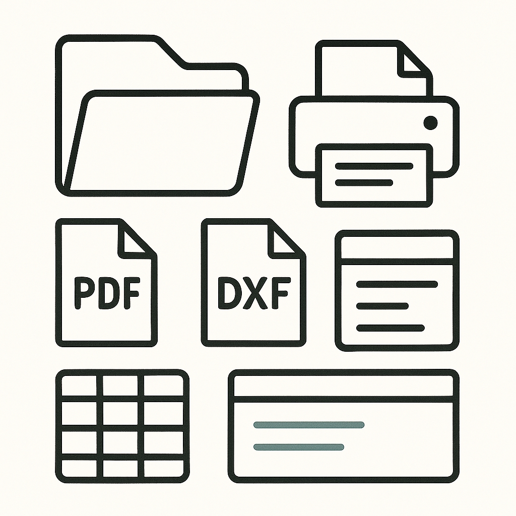
Print and Export
High-quality plotting with provided CTB pen tables for all scales. ● Generate PDF by 2 clicks only ● DXF export for part of the drawing ● Any Textfile preview panel ● Pen tables (CTB) for every plot scale.
Read more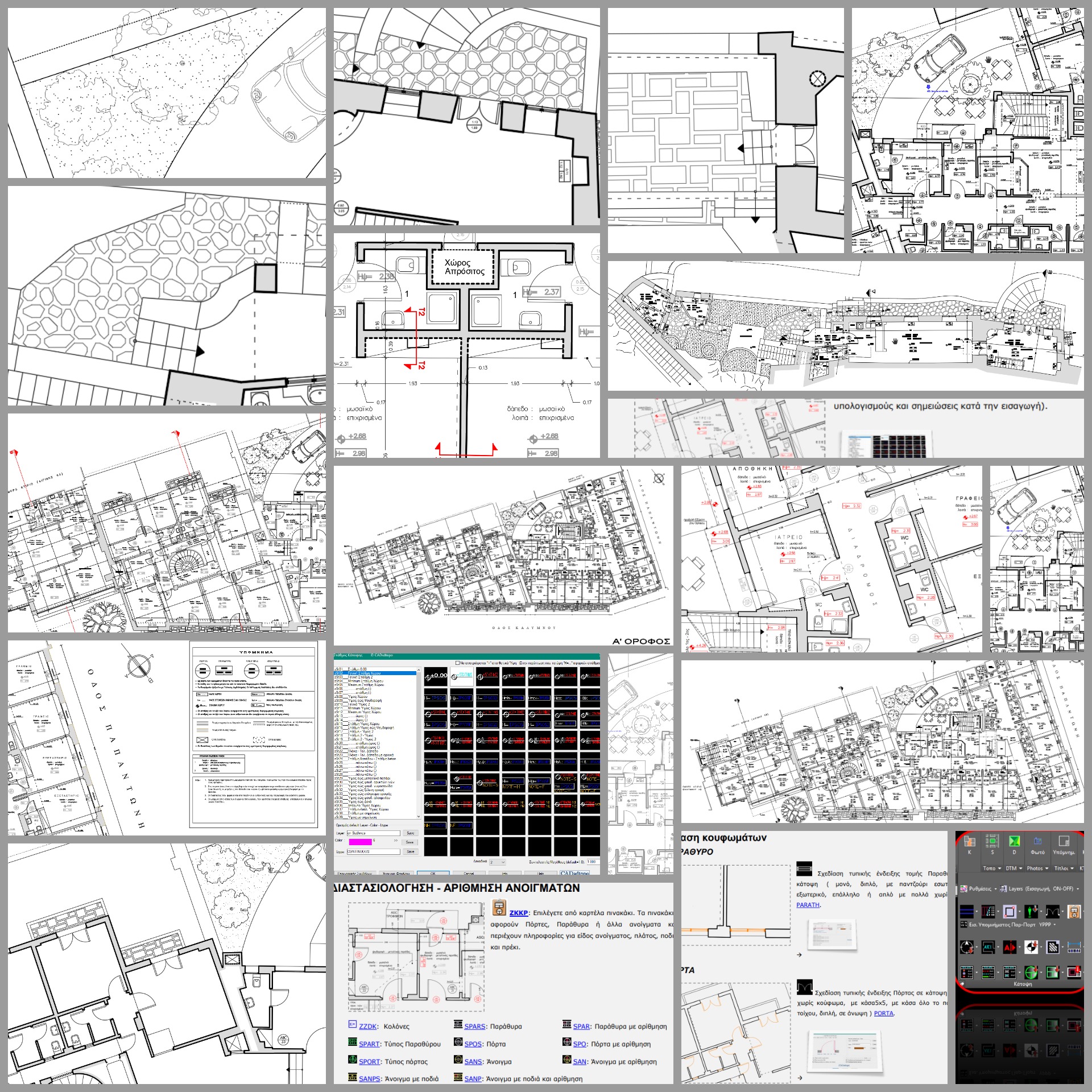
Building Survey Floor Plans
A complete workflow for drafting building survey and as-built floor plans quickly and consistently. All drawing elements — texts, symbols, tags, dimensions, hatches, titles and notes — are inserted with scale-aware sizing. ● Automatic layer creation for single or multi-level plans ● Filter & LMAN setup ● Section and projection lines (20 styles) ● Stair tool with automatic offset ● Directional arrows ● Architectural symbols ● Automatic door and window generation ● Opening dimension tags with automatic calculations ● Column, wall and beam tags ● North symbols and directional markers ● Room, space usage and material annotations with scale and layer automation ● Notes and indication tools ● Auto-calculated level markers for floors, ceilings, beams and level changes ● Hatch patterns for building materials and surfaces ● Dimensioning ● Legends for lines, symbols and hatches ● Symbol-in-circle and tabular formats ● Title and header insertion ● One-click PDF export with high-quality output.
Read more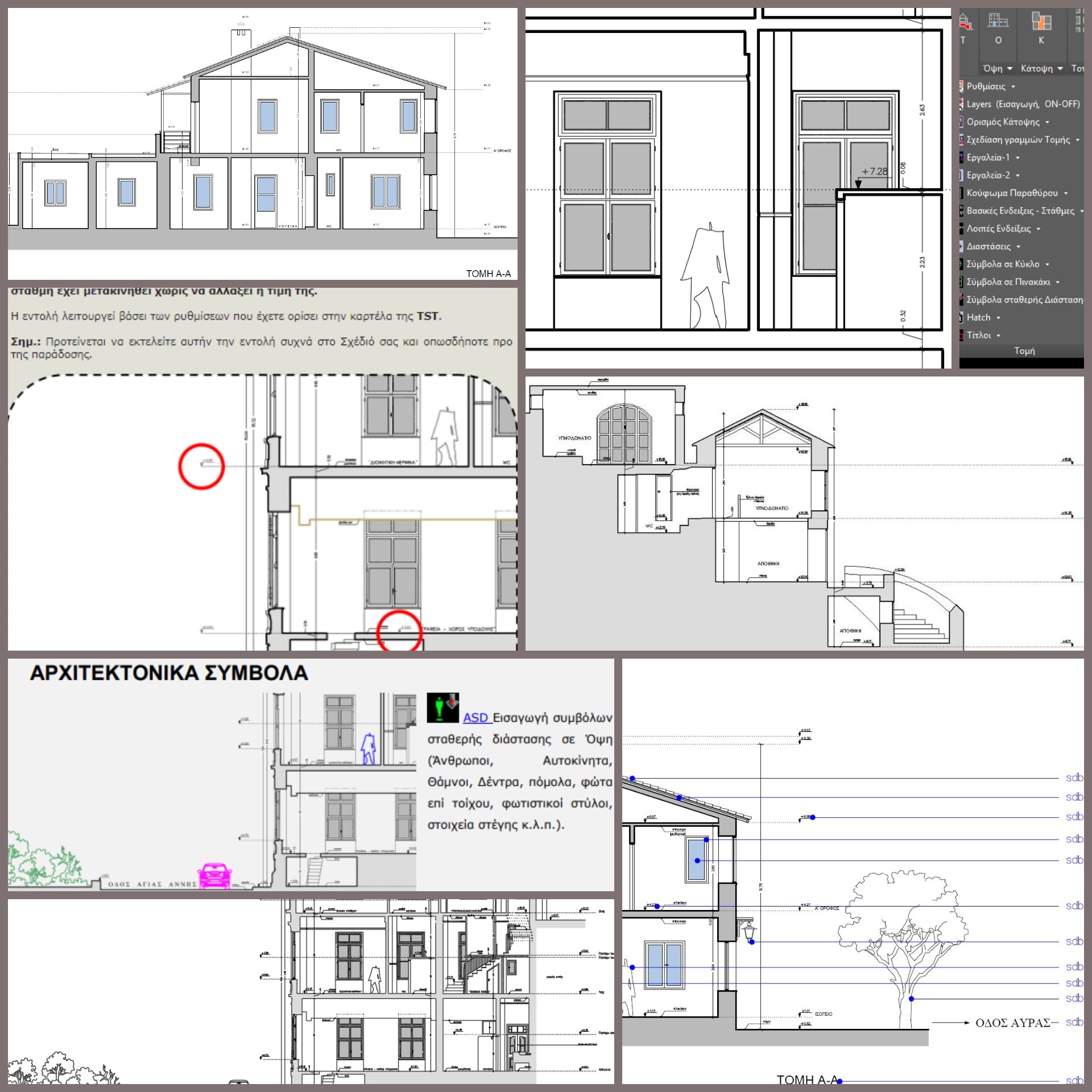
Building Survey Sections & Elevations
A complete workflow for drafting building survey / as-built sections and elevations directly from floor plans. Includes automation tools and step-by-step drafting aids for fast and consistent results. ● Automatic layer setup ● Insertion, rotation and positioning of floor plan as Xref ● Section and projection line tools ● Split-screen workflow for drafting from plan geometry ● Fast section/elevation drafting from the floor plan ● Automatic stair drawing in section and elevation ● Copy tools for selected elements from Xref ● Auto-generated doors and windows in elevations and sections ● Datum level, level markers and height references ● Annotations, notes and symbols ● Hatch patterns for materials and surfaces ● Dimensioning tools ● Title and header insertion.
Read moreEditions & Pricing
Choose the edition that matches your CAD platform and workflow. SDBOX Survey focuses on complete topographic survey drawings, terrain, maps and GIS/CAD exchange; SDBOX Construction adds building survey and set-out tools.
For full functionality, a complete CAD edition is required: AutoCAD 2016+ / BricsCAD V20+ / GstarCAD 2021+ / ZWCAD 2021+ / progeCAD 2026+ (not Light or Standard).
Survey
Complete topographic survey drawings, DTM, maps and GIS/CAD exchange
250€ + Tax
Includes:
Basic + Survey Plan + DTM + Google Earth + Maps
PurchaseConstruction
Survey tools plus building surveys, sections/elevations and setting out
350€ + Tax
Includes:
Survey + Floor Plans + Sections & Elevations + Set-out Plan tools
PurchaseBasic
General drafting, KML/KMZ, SHP and JSON handling, texts, symbols, line management, hatch patterns, drawing views, annotations, dimensions, image management, layers, calculations, photographs and other core day-to-day CAD utilities.
Survey
Complete topographic survey drawings, DTM, maps and GIS/CAD exchange
200€ + Tax
Includes:
Basic + Survey Plan + DTM + Google Earth + Maps
PurchaseConstruction
Survey tools plus building surveys, sections/elevations and setting out
280€ + Tax
Includes:
Survey + Floor Plans + Sections & Elevations + Set-out Plan tools
PurchaseBasic
General drafting, KML/KMZ, SHP and JSON handling, texts, symbols, line management, hatch patterns, drawing views, annotations, dimensions, image management, layers, calculations, photographs and other core day-to-day CAD utilities.
Notes for BricsCAD
- Automatic layer update in many LMAN is not yet available.
- A security warning about the execution of SDBOX ActiveX controls may appear frequently, without however preventing the commands from running correctly.
- When the command line is not visible on the main screen, some commands, such as ZVPMW, may terminate prematurely.
- Some image-related commands, such as ZIMDETACH and ZFIM, are not supported.
Survey
Complete topographic survey drawings, DTM, maps and GIS/CAD exchange
200€ + Tax
Includes:
Basic + Survey Plan + DTM + Google Earth + Maps
PurchaseConstruction
Survey tools plus building surveys, sections/elevations and setting out
280€ + Tax
Includes:
Survey + Floor Plans + Sections & Elevations + Set-out Plan tools
PurchaseBasic
General drafting, KML/KMZ, SHP and JSON handling, texts, symbols, line management, hatch patterns, drawing views, annotations, dimensions, image management, layers, calculations, photographs and other core day-to-day CAD utilities.
Notes for progeCAD
- After installing progeCAD, run progeCAD once as Administrator before the first use of SDBOX. This is required only once, so that progeCAD can complete its ActiveX/COM registration.
- Double-clicking on SDBOX tabs/lists is not available. Instead, select the item and click OK.
- Layer descriptions and bulk LMAN updating are not available.
- Export to Google Earth is supported for all object types except images.
- Automatic extract generation is not available yet, but the ''Step-by-step extract'' workflow is supported.
- When the drawing view is rotated, ZZPDF command may export an empty area. In this case, run PLOT and select only the print window again.
Survey
Complete topographic survey drawings, DTM, maps and GIS/CAD exchange
200€ + Tax
Includes:
Basic + Survey Plan + DTM + Google Earth + Maps
PurchaseConstruction
Survey tools plus building surveys, sections/elevations and setting out
280€ + Tax
Includes:
Survey + Floor Plans + Sections & Elevations + Set-out Plan tools
PurchaseBasic
General drafting, KML/KMZ, SHP and JSON handling, texts, symbols, line management, hatch patterns, drawing views, annotations, dimensions, image management, layers, calculations, photographs and other core day-to-day CAD utilities.
Notes for GstarCAD
- The ZSW and ZSB commands for changing screen color are not available.
- For text alignment, the ZETT command should be used instead of ETT.
Survey
Complete topographic survey drawings, DTM, maps and GIS/CAD exchange
200€ + Tax
Includes:
Basic + Survey Plan + DTM + Google Earth + Maps
PurchaseConstruction
Survey tools plus building surveys, sections/elevations and setting out
280€ + Tax
Includes:
Survey + Floor Plans + Sections & Elevations + Set-out Plan tools
PurchaseBasic
General drafting, KML/KMZ, SHP and JSON handling, texts, symbols, line management, hatch patterns, drawing views, annotations, dimensions, image management, layers, calculations, photographs and other core day-to-day CAD utilities.
Notes for ZWCAD
- In versions earlier than 2025, functionality is limited, and commands such as SAA, which is used to turn surveyed point elevations on and off, is not available in versions earlier than 2024.
- Commands related to LMAN are not supported.
- In versions earlier than 2025, contours are generally drawn correctly, but when the number of triangles is large, they may in some cases be created at Z=0.
Additional licenses: A 25% discount applies to each additional key, with a minimum charge of 150€ + Tax per license.
Samples – Guides & Examples
Free Trial
Download the SDBOX demo for the CAD platform you use and evaluate it directly inside your own working environment.
For the best experience and full functionality, BricsCAD, GstarCAD and ZWCAD perform best in version 2025 and later. progeCAD is supported from version 2026 and later.
System requirements
Requires Windows 10 or Windows 11 and a full CAD edition: AutoCAD 2016+ / BricsCAD V20+ / GstarCAD 2021+ / ZWCAD 2021+ / progeCAD 2026+ (not Light or Standard).
CAD production workflow: SDBOX is designed around metric CAD production standards and metric-based drawing presets.
Required disk space: 3 GB
Load into CAD: After the installation wizard finishes, CAD will open automatically. Once it opens, type APPLOAD, select the file C:\sdbox_Tools\_CADsdbox.lsp, and click Load.
Helpful links
Purchase SDBOX
Build your purchase request according to the CAD platform, edition and number of licenses you need. Prices follow the Editions section exactly and show net value, tax and total.
SDBOX works with a USB Token. The software may be installed on multiple computers at the owner’s office, and it will operate on whichever computer has the token connected.
Additional licenses: 25% discount applies to extra keys, with a minimum charge of 150€ + Tax per seat.
The details below are used to prepare the customer record and the purchase request.
Customer details
Cost summary
The button below generates a complete purchase request with all selected items and customer details, and then takes you to the confirmation step.
Purchase request confirmation
Your purchase request is ready.
Please review the details below before submitting your purchase request.
After submission, the SDBOX team will contact you with the next steps for completing your order.
Selected items summary
Customer details
Please note that, before an SDBOX license can be activated, the corresponding trial version must first be installed. If you have not already done so, you can download the trial version and use SDBOX normally until your license activation key is sent to you.
Go to Demo AppsContact & Support
Quick message
We will get back to you within 24 hours.